|
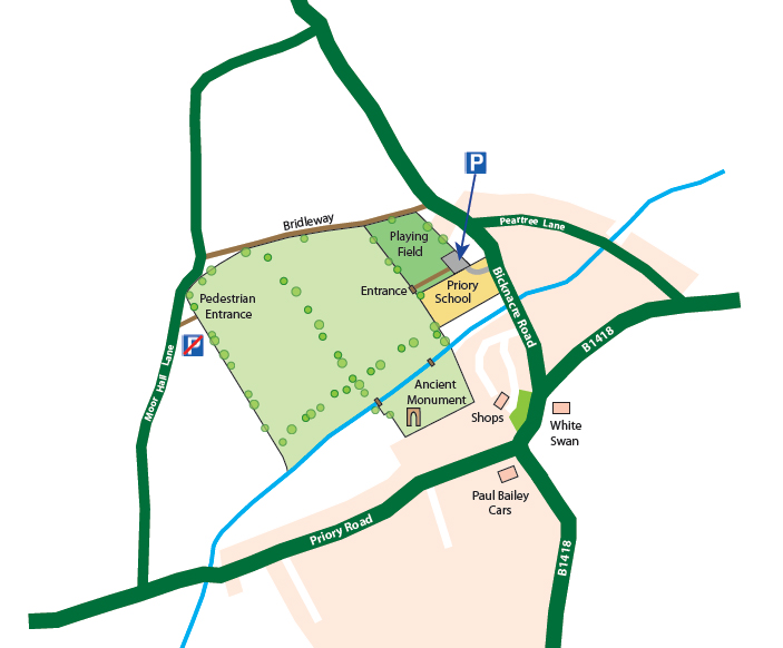
Priory Fields is accessed by passing through the car park of Priory School to the village hall car park beyond. Please park here. Then walking along the side of the playing field to the entrance.
|
|
|
By Car:
|
- •
From A12 junction18 take A414 to Danbury. Turn right by village green towards Bicknacre. Bear left across Danbury Common. In Bicknacre village turn right into Priory School.
- • From South Woodham Ferrers take B1418 towards Danbury, fork left at White Swan, turn left into Priory School.
- • From Maldon take A414 to Oak Corner roundabout, Claremont Nursery. Take 2nd exit, B1418 to Bicknacre. At White Swan turn right then left into Priory School.
|
|
|
By Bus:
|
- • From Chelmsford Rail/Bus station Route 36 via Great Baddow and Danbury to Bicknacre, White Swan. Walk back to Priory School.
- • From South Woodham Ferrers Route 36 via South Woodham Rail Station to Bicknacre, White Swan. Walk on to Priory School.
- • From Maldon Route 31 to Danbury then Route 36 to Bicknacre, White Swan. Walk back to Priory School.
|
|
|
Walking:
|
- • Take Bicknacre Road towards Danbury, for approximately 300m north of the White Swan, to Priory School. Turn left onto the footpath along the right side of the school car park.
- • Cross the upper car park and follow the fence along the side of the school playing field. You will see the main entrance to Priory Fields ahead of you.
|